


Camp 2024 - lac des confins depuis le chalet.

norbertmarteau
User
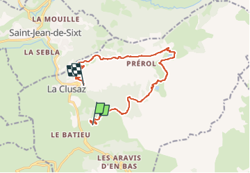

Length
13.4 km

Max alt
1582 m

Uphill gradient
373 m
Km-Effort
19.4 km

Min alt
1080 m

Downhill gradient
681 m
Boucle
No
Creation date :
2024-08-08 17:33:06.0
Updated on :
2024-08-08 17:33:07.451

FREE GPS app for hiking
 SityTrail
IGN / Geographical institutes
SityTrail Plus
The world is yours!
About
Trail of 13.4 km to be discovered at Auvergne-Rhône-Alpes, Upper Savoy, La Clusaz. This trail is proposed by norbertmarteau.
Positioning
Country:
France
Region :
Auvergne-Rhône-Alpes
Department/Province :
Upper Savoy
Municipality :
La Clusaz
Location:
Unknown
Start:(Dec)
Start:(UTM)
301167 ; 5085246 (32T) N.
Comments